 Filter: Categories of Wisconsin Historical Images
Filter: FORMAT_DIMENSIONS of 23.75 x 30 inches
Filter: Categories of Wisconsin Historical Images
Filter: FORMAT_DIMENSIONS of 23.75 x 30 inches
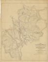
| Date: | 1862 |
|---|---|
| Description: | This map of the area between Monterey, Tennessee, and Corinth, Mississippi, shows Union lines of entrenchment in blue and Confederate lines around Corinth ... |
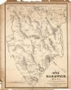
| Date: | 1833 |
|---|---|
| Description: | The map shows the distance of each dwelling-house from the common. The dwellings are listed by name of owner. |
If you didn't find the material you searched for, our Library Reference Staff can help.
Call our reference desk at 608-264-6535 or email us at: